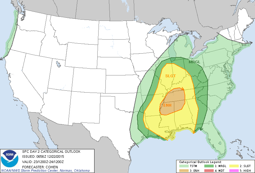
The National Storm Prediction Center has included most of the Chicago area in a risk of severe thunderstorms Wednesday (see Wednesday severe weather outlook map above). The southern portion of the Chicago area rests in the northern edge of a Slight Risk of severe thunderstorms that includes most of southern and central Illinois/Indiana (yellow-shaded area on map above).
Most of the remainder of the Chicago area is under a Marginal Risk of severe thunderstorms Wednesday (dark-green-shaded area on the severe weather outlook map above). Note the greatest risk of severe thunderstorms and possible tornadoes is an Enhanced Risk area that is centered over portions of Tennessee, Mississippi and Alabama (tan-shaded area on severe weather weather outlook map above).
A cold front will approach our area from the west Wednesday with a strong low-level jet pulling warm moisture-laden air all the way north from the Gulf of Mexico up the Mississippi Valley into the the Ohio Valley and portion of the Midwest, including Illinois.
This will create an unusually mild day here with temperatures rising into the 50s and lower 60s and associated dew points in the 50s. Southerly winds will increase – gusting over 30 miles per hour. As the cold front draws closer, convergence of all these parameters combined with an upper-air impulse aloft is forecast to trigger north-south-oriented lines of strong to severe thunderstorms that could occur as far north as the Chicago area – mainly in the afternoon hours Wednesday. The cold front should sweep through our area, ending the thunderstorm threat from west to east later in the afternoon and evening.